Challenge:
Disasters hurt the poor and vulnerable the most. Since 1980, more than two million people and over $3 trillion have been lost to disasters caused by natural hazards, with total damages increasing by more than 600% from $23 billion a year in the 1980s to $150 billion a year in the last decade. From 1998 through 2018,91% of storm-related fatalities were in low-and middle-income countries, even though these countries experienced just 32% of storms. In 2020, the COVID-19 pandemic is disrupting the world with a heavy toll on human lives and economic activities. Its rapid global spread is threatening to affect millions of people already made vulnerable by food insecurity, malnutrition and the effects of conflict and other disasters, and has caused global disruptions to the transport systems and links that health and humanitarian responders would normally rely upon to reach affected areas in a crisis. Meanwhile, many developing countries are still facing a variety of disaster risks such as earthquake, drought, etc. Specifically, nowadays China is experiencing the flood season and focus on flood prevention and relief with high level emergency response. Disaster is the common challenge for economic and social development of developing countries around the world. Over one billion Asians still live under the international poverty line of $3.20 per day and the corona virus may drive an addition $100 million over the threshold.

Solution:
Digitalized Risk Surveillance:
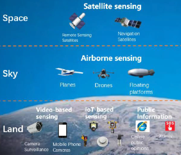
The Chinese government has promoted the application of information technology in its emergency management, including disaster perception network, emergency communication network, application of information technology in emergency command, disaster monitoring and early warning, workplace safety monitoring and early warning, and risk investigation and hidden danger investigation. There is a framework consisted of a monitoring and early warning sensing network integrating space, sky and land and big data system for emergency management for digitalized risk surveillance in China. The system for emergency management information and resources governing system has been established basically, enabling data governance characterized by full data access, efficient data processing, fine management, and multiple services.
To offer comprehensive natural disaster monitoring and early warning services, sensing techniques have been adopted, including intelligent sensors, video imagery, satellite remote sensing, airborne remote sensing, and public sensing(disaster information reported by the public), which form an integrated, full-coverage“space-sky-land”monitoring and early warning sensing network that enables full awareness of all hidden risks and disaster information.
Big Data System for Emergency Management. Data accessed from MEM departments and subordinate units, provincial departments, other ministries, social organizations and internet. Then data will be dealt with series of procedures and to be categorized by raw data, resource data, subject data and theme data. There also are big data-supported functions to further deal with these four kinds of data through platform, application, equipment and model. Finally, big data could be for intelligent applications, including Surveillance Management, Monitoring and Early Warning, Guidance for Rescue Operation,Policy Support, and Administrative Affairs Management.
Big Data Application:

1. Satellite Remote Sensing Monitoring of Disaster Risk. There are two kinds of remote sensing monitoring:regular monitoring of major elements and risk of disasters, as well as post-disaster recovery and reconstruction; completing regular monitoring reports, and emergency monitoring of the background, scope, damage and secondary risk of major natural disasters as well as completing emergency monitoring reports. Also, the Sky Eye Satellite Monitoring System precisely predicts satellite passes and the imaging plan, allows for the checking and comparison of the developments of disaster supported by disaster information and satellite data, analyses the disaster using AI technology, and produces thematic maps automatically.
2) Flood and Drought Monitoring and Early Warning, including disaster scenarios model, early warning information, integrated query, and rescue analysis.
3) One Map system for Disaster Prevention and Early Warning. The One Map system is an“Internet+”model of intelligent disaster early warning, functioning as a national center of national disaster risk early warning and analysis, as well as a“portal”serving the public in this regard.
4) Analysis for the Evacuation of Disaster-affected Population. To verify disaster information based on population data, we would analyse the location data provided by telecom operators and Internet companies, to figure out the number of specific people affected and those to be evacuated, as well as the relocation sites.
5) Recognition and Extraction of Remote Sensing Imagery.The flooded houses and the area covered by affected crops in specific disaster-hit areas will be analyzed, which is enabled by the recognition of high-resolution remote sensing imagery.
6) Rapid Disaster-information Acquisition Based on Big Data. There are multiple channels for collecting real-time images of disaster/accident sites. Big Data Based on Mobile Communication means that China Unicom uses the real-time cellar signaling data of 31 provinces in the whole network to analyse the distribution, flow, transfer and resettlement of the population in various disaster-stricken areas in China. Big Data Based on Social Media. Use big data provided by social media to analyse the disaster information needs of various users in disaster-hit areas and provide accurate disaster information services to users.
7) UAV Monitoring of Disaster Risk. UAV cooperation mechanism for emergency monitoring of major natural disasters, with UAV companies across the country engaged in, provides technical support for UAV data acquisition and post--disaster evaluation of the monitoring.

8) Collecting and Reporting Disaster Information on Site. National natural disaster information management system(NNDIMS)provides natural disaster reporting service by ground wired internet and mobile internet, which supports disaster reporting at provincial, municipal, county, township and village level. NNDIMS receives more than 100,000 disaster reports every year. Sudden disasters are basically reported to emergency departments within 12 hours after they occur. More than 50% of the reports are submitted within 6 hours after disasters. Single disaster is reported more than 4 times on an average basis. More than 700,000 disaster information reporters are responsible for collection and reporting of disaster information.The information reported by them is dynamically managed and updated by database. BeiDou system realizes that once the ground communication is interrupted, the disaster situation can be directly reported to NDRCC by Bei Dou SMS, and automatically decoded and translated into NNDIMS database. R4 Rural Resilience Initiative: An Integrated Risk Management Strategy incorporates 4 components:
1. Risk Reduction through Climate Smart Agriculture
2. Risk Transfer
3. Prudent Risk Taking: R4 has partnered with Vision Fund (VFZ)to develop an adequate credit product to be marketed to farmers commercially, meaning that they will have the option to apply for it and be selected based on eligibility.
4. Risk Reserves: Cash and in-kind savings
Original Link:
Reduction·Response·Resumption: Good Practice on Disaster Risk Reduction Management
Category
Disaster Risk Reduction Management
Contributor
Disaster Risk Reduction Management
Country
Technical Solution

